Friday, December 9, 2011


Wednesday, October 26, 2011
Lansing Park
In the early 1930’s, William Yates Lansing  purchased a half interest in the Chester G. Ham coal business, at the end of Central and Forbes Avenues, along the Hudson River in Rensselaer, NY.

Lansing acquired full control of the business two years later, and his coal, lumber and hardware business operated in Rensselaer for decades.
Lansing grew up on a farm in Glen, Montgomery County. From Lansing's biography in "Troy and Rensselaer County, New York, a History" (1925, pg. 120):
Lansing bought part of the old Van Rensselaer farm on the southerly side of Forbes Ave., where he had a large home with a pond for ducks and swans. Lansing also owned land across the street in the Little Farms neighborhood. At his “Gypsy Camp Farm”,
  Lansing bred White Holland turkeys and White Plymouth Rock chickens.
In the 1930’s, Lansing even raised and sold peacocks, which must have been quite a sight. From the Geneva Daily Times, June 1, 1936:
W. Yates Lansing died in 1938, and the land south of Washington Ave. was subdivided to become Lansing Park in 1947. The streets are Hazel, William, and Wallace Terraces, and Farley Drive, which was formerly known as Lansing Drive. Hazel Terrace was likely named for Lansing’s second wife Hazel, but the origin of the other names is uncertain. Does anyone know more?
 purchased a half interest in the Chester G. Ham coal business, at the end of Central and Forbes Avenues, along the Hudson River in Rensselaer, NY.
Lansing acquired full control of the business two years later, and his coal, lumber and hardware business operated in Rensselaer for decades.
Lansing grew up on a farm in Glen, Montgomery County. From Lansing's biography in "Troy and Rensselaer County, New York, a History" (1925, pg. 120):
In addition to all his other interests, Mr. Lansing is a practical farmer. He never ceased to enjoy farm life and agricultural work, and not long after he came to Rensselaer, he purchased a small farm comprising several acres of the finest agricultural land in the county.
Lansing bought part of the old Van Rensselaer farm on the southerly side of Forbes Ave.,
 where he had a large home with a pond for ducks and swans. Lansing also owned land across the street in the Little Farms neighborhood. At his “Gypsy Camp Farm”,
  Lansing bred White Holland turkeys and White Plymouth Rock chickens.
In the 1930’s, Lansing even raised and sold peacocks, which must have been quite a sight. From the Geneva Daily Times, June 1, 1936:
W. Yates Lansing, who owns a peacock farm near here, said today he believed it to be the only one of its kind in New York State. There are 31 peacocks, mallard ducks and two swans on the farm. Most of the peacocks are of the blue, or common type, but included in the flock are two white ones and two green birds, the latter imported from Java. Lansing said the birds are no more trouble to raise than turkeys.

W. Yates Lansing died in 1938, and the land south of Washington Ave. was subdivided to become Lansing Park in 1947. The streets are Hazel, William, and Wallace Terraces, and Farley Drive, which was formerly known as Lansing Drive. Hazel Terrace was likely named for Lansing’s second wife Hazel, but the origin of the other names is uncertain. Does anyone know more?
This is final part of the series: North End Park Neighborhoods (download this as a free PDF here)
Wednesday, October 12, 2011
"My River Chronicles" by Jessica DuLong
I was disappointed to miss the Waterford Tugboat Roundup this year (canceled due to Hurricane Irene). But this book more than made up for it - I highly recommend putting it on your holiday wish list.
From the inside flap:
In 2001, journalist Jessica DuLong ditched her dot-com desk job for the diesel engines of a rusty antique fireboat, the John J. Harvey, and the storied waters of the Hudson River.
From the inside flap:
In 2001, journalist Jessica DuLong ditched her dot-com desk job for the diesel engines of a rusty antique fireboat, the John J. Harvey, and the storied waters of the Hudson River.
Thursday, October 6, 2011
Altamont Art In The Park - Saturday
It's not too soon to start thinking about shopping for the holidays, and it's not too late for a lovely outdoor craft fair on a beautiful autumn day. Art In The Park is a juried show, happening this Saturday, from 10am to 6pm on the green in Altamont, NY.
The publicity says "The various artists range from glass to fiber art, watercolors to oils and pottery to photography with a few woodworkers and a jeweler or two thrown in for good measure!" My beau is one of the woodworkers, so stop by and say Hello - I'll be helping him at the Quiltboxes tent.
The event is sponsored by Desolation Road Studios and the Altamont Free Library. Kudos to Jim Miller of Desolation Road for all his hard work organizing this event! (FYI, most of the artists in the show have items for sale in the shop at Desolation Road, on the green in Altamont.)

What: Art In The Park, Juried Art/Craft Show
When: Saturday, Oct. 8th, 10am - 6pm
Where: Village green, Altamont, NY [map]
Free Concert: 3 - 5pm, features the 3J’s
This event was originally scheduled for last Saturday, but thankfully Jim invoked the rain date. The forecast for this Saturday is gorgeous - sunny and in the 70's. Please come on over, and enjoy some early autumn color on the scenic drive to Altamont.
Sunday, October 2, 2011
The Golden Age of Coal Smoke
I've been reading Booth Tarkington's novels, and they often complain of an aspect of the "golden age" of rail and industry that was certainly mirrored here in Rensselaer 100 years ago - the problem of soft coal smoke.
This article from the Rensselaer Eagle, Aug. 8, 1912 illustrates one reason why Rensselaer's North End park neighborhoods, built far from the rail yards, were so popular.
 aspect of the "golden age" of rail and industry that was certainly mirrored here in Rensselaer 100 years ago - the problem of soft coal smoke.
The smoke was one of his great enthusiasms; he laughed at a committee of plaintive housewives who called to beg his aid against it. "Smoke's what brings your husbands' money home on Saturday night," he told them, jovially." [The Turmoil, 1915]
"Prosperity" meant good credit at the bank, black lungs, and housewives' Purgatory. The women fought the dirt all they could; but if they let the air into their houses they let in the dirt. It shortened their lives, and kept them from the happiness of ever seeing anything white. [The Magnificent Ambersons, 1918]
This article from the Rensselaer Eagle, Aug. 8, 1912 illustrates one reason why Rensselaer's North End park neighborhoods, built far from the rail yards, were so popular.
The Delaware and Hudson Railroad advertised that their passenger trains to the Adirondack Mountains and Montreal burned the cleaner (and more costly) "anthracite coal only...no smoke".BLACK SMOKE NUISANCE COULD BE ABOLISHED
Rensselaer Suffers Much From Cloud Belching From Engines
Roundhouse Belches Smoke Continuously all Day and all Night - New York Central Has to Adjust Many Claims Because of Smoke.Now that the city of Troy has succeeded in reducing the soft coal smoke nuisance to a minimum it is up to the people of this city to take similar action. Rensselaerites are a long suffering people and they have suffered to no small extent because of the fact the New York Central engines use soft coal and emit black, sooty smoke.
Residents have complained time and again of the soft coal smoke nuisance. It not only covers every portion of the city, from one end to the other, but the fact that the railroad companies are permitted to use soft coal within the city limits doubtless keeps away people who would otherwise live in this city.
ROUNDHOUSE SMOKE
The roundhouse on the Hudson island is perhaps the greatest evil so far as soft coal smoke is concerned in the city. It is bad enough to have long freight trains, switching engines and passenger engines moving through the railroad yards, but the roundhouse never stops and there is always a cloud of smoke issuing from there night and day.
...
There are lots of women in this city who can testify to the effects of soft coal smoke on their clothing. There are not many women, who, wearing dainty summer clothing, would walk the Maiden lane or upper bridges at any time because they are afraid of having their clothing ruined by the smoke. The smoke is often filled with enough moisture to make it very sticky and when it covers one as he walks the bridge, the effect is far from pleasing.
...
In many sections of the city unless an east wind prevails it is an unwise housewife who would think of putting her washing out to dry. The majority of them are forced to have washed clothes dried in the house year in and year out.
The smoke is also bad for paint, as a glance at many buildings adjacent to the railroad will show. But very few houses are painted a light color, for the reason that there being so much smoke in the air it would soon discolor the paint. This is one of the reasons why so many buildings, especially those near the railroad are painted in dark and sombre colors....

Sunday, September 25, 2011
Education Center Opens at BASF Site
Times Union: From a landfill, an oasis springs, Sept. 22, 2011
Transforming a Brownfield Site (includes interviews with Karen Urbanski, Rensselaer Middle School Principal, and Mayor Dan Dwyer)
BASF Environmental Education Classroom and Wildlife Habitat (The company makes many of the building materials used in this demonstration project, so most of these videos are long-format advertisements for their products, but the construction details are interesting.)
FYI, BASF makes an herbicide to deal with that invasive purple loosestrife in their native wildlife habitat (but nobody told their videographer...)
Chemical company BASF has transformed the site of its former manufacturing plant into 10 acres of wildlife habitat with an education center and 40 acres of land available for redevelopment.The Record: Former landfill transformed into environmentally conscious education center, wildlife habitat VIDEO
BASF invested more than $20 million in the environmental investigation and cleanup of the property which now includes a small building made with local materials...Press Release: BASF opens new environmental education classroom and wildlife habitat in Rensselaer, New York
The environmental education classroom is a new building that is a model for sustainable construction and has been registered with the United States Green Building Council (USGBC) with the goal of obtaining Leadership in Energy and Environmental Design (LEED®) Platinum certification.This project, just north of the Besicorp Empire Generating plant, is extensively documented by BASF, with many images and videos including:
Transforming a Brownfield Site (includes interviews with Karen Urbanski, Rensselaer Middle School Principal, and Mayor Dan Dwyer)
BASF Environmental Education Classroom and Wildlife Habitat (The company makes many of the building materials used in this demonstration project, so most of these videos are long-format advertisements for their products, but the construction details are interesting.)
FYI, BASF makes an herbicide to deal with that invasive purple loosestrife in their native wildlife habitat (but nobody told their videographer...)
Tuesday, September 20, 2011
RoadTrip: MakerFaire NYC 2011
I went to MakerFaire NYC last Saturday to window shop for a 3D printer. Imagine this as a huge science fair, sponsored by Radio Shack ("learn to solder here!"). If you make some cool sort of robotic, electro-mechanical, or steampunky gizmo, you can show it off at MakerFaire...
 To get a flavor for the event, start with this video of Random Vehicles (and their drivers) outdoors on the former Worlds Fair grounds. There was lots more to see inside the New York Hall of Science:
 The antique iPad keyboard was great!


A couple of contrasting dreams of flight:


MakerBot TV made a nice video of the 3D fabrication village. And one last video link, because you don't want to miss the Coke Zero and Mentos show!
 To get a flavor for the event, start with this video of Random Vehicles (and their drivers) outdoors on the former Worlds Fair grounds. There was lots more to see inside the New York Hall of Science:
 The antique iPad keyboard was great!
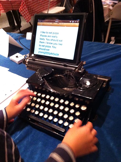

A couple of contrasting dreams of flight:


MakerBot TV made a nice video of the 3D fabrication village. And one last video link, because you don't want to miss the Coke Zero and Mentos show!
Wednesday, September 14, 2011
The George E. Hatcher House
When I bought this house, it was so unique I had to find out who built it and what Rensselaer was like back then. (I started this blog to document the cool things I learned.) I wish all Rensselaer's intriguing homes could tell their stories, but here is the history of the George E. Hatcher House.  Please follow the link to check it out!
And if you'd like to live in a unique home that also illustrates a great time in Rensselaer's history, Hatcher House is for sale, and there's an Open House planned this Sunday, Sept. 18, from 2:30-4pm.
 Please follow the link to check it out!
And if you'd like to live in a unique home that also illustrates a great time in Rensselaer's history, Hatcher House is for sale, and there's an Open House planned this Sunday, Sept. 18, from 2:30-4pm.
Eastland Park
The land for Eastland Park was part of the farm leased in 1790 by Martinus Sharpe, an early settler of Defreestville. The land was later owned by one of the DeFreest families, who sold it to Patrick Dunn in 1897.
In 1927, the Dunn farm was sold to Charles Wenz, Henry Meurs, Thomas Sherwood, Jr. and Dolfie Shufelt. Together with lawyer Ernest L. Boothby, these men formed the Eastland Park Association. This ad appeared in the Albany Evening Journal, Sept. 14, 1927 (click to zoom in).
Dolfi Shufelt, the president of the Association, had been a partner in Leahey & Shufelt, the masons and contractors on high-profile projects like the county bank building and the city reservoir. Leahey & Shufelt also developed the Lincoln Terrace neighborhood.
Charles Wenz worked as a roofer. Henry Meurs had served as Mayor of Rensselaer (1920-21) and as a NYS Assemblyman, and he owned Henry Meurs and & Sons Hardware.
Their plan included a man-made lake and a market plaza: Though the Eastland Park Association never built the lake, they kept the name Lakeview Avenue. Market Street was renamed Woodland Avenue.
Today the park offers a playground, baseball diamond, and basketball and tennis courts, and hosts summer picnics. The Rensselaer City History Research Center has records of the Eastland Park Association, for those wanting to do further research.

In 1927, the Dunn farm was sold to Charles Wenz, Henry Meurs, Thomas Sherwood, Jr. and Dolfie Shufelt. Together with lawyer Ernest L. Boothby,
 these men formed the Eastland Park Association. This ad appeared in the Albany Evening Journal, Sept. 14, 1927 (click to zoom in).
Dolfi Shufelt, the president of the Association, had been a partner in Leahey & Shufelt, the masons and contractors on high-profile projects like the county bank building and the city reservoir. Leahey & Shufelt also developed the Lincoln Terrace neighborhood.
Charles Wenz worked as a roofer. Henry Meurs had served as Mayor of Rensselaer (1920-21) and as a NYS Assemblyman, and he owned Henry Meurs and & Sons Hardware.
Their plan included a man-made lake and a market plaza:
...on healthy, high ground where nature has combined with development progress to make this section attractive and desirable for discriminating home site seekers… A feature of the development is the beautiful grove which is planned for a park and will be deeded to the city... Here will be found scenic beauty unequaled.
 Though the Eastland Park Association never built the lake, they kept the name Lakeview Avenue. Market Street was renamed Woodland Avenue.
Today the park offers a playground, baseball diamond, and basketball and tennis courts, and hosts summer picnics. The Rensselaer City History Research Center has records of the Eastland Park Association, for those wanting to do further research.

Friday, September 9, 2011
Van Allen Park
Just west of Defreestville, the "rock cut" allows the road to pass through the rocky ridge that once bisected the 400 acre farm of John Evert Van Alen. Van Alen owned a general store in Greenbush, and was a U.S. Congressman from 1793 to 1799. He was also a surveyor who did work for the Patroon, and he surveyed part of the Eastern Turnpike.
 John E. Van Alen had no children, and his nephew Evert Van Alen was heir to his estate. Evert was also a surveyor and civil engineer, and helped build the Erie Canal. Evert’s will split the farm between sons John and Stephen.
 Stephen V. R. Van Alen inherited the western 90 acres, between the ridge and the farm of William P. Van Rensselaer. Stephen built the beautiful “Rock Hill” house west of the ridge.
In 1907, Stephen’s daughter Elizabeth V.A. Lape acquired the land from her sister Catherine, who had cared for their elderly father. In 1926, Elizabeth sold the land for this neighborhood to Bruce Corlis of Corliss Realty, Inc., St. Alban’s, VT.
Corliss filed a map in 1926, and the street names he used for Van Allen Park were: Delaware, Maryland, Illinois, Wisconsin, Indiana, Michigan, Ohio, Iowa, Missouri, Florida, California, and Minnesota Avenues. Apart from the lots closest to Washington Ave, most of this neighborhood is actually in North Greenbush. Corliss created decades of address confusion when he duplicated many of the same street names in his 1925 Sherwood Park development, located off Columbia Turnpike in East Greenbush.
For more about the Van Alen family, read "Background and Social History of the site and Occupants of the John Evert and Anne Fryenmoet van Alen House", by Walter Richard Wheeler, Hartgen Archeological Associates, Inc.
Saturday, August 27, 2011
DEC OK's Waterfront First Phase
Times Union: DEC weighs in on Rensselaer waterfront plan
The state Department of Environmental Conservation has approved the beginning of a massive development project planned for the Rensselaer waterfront on property where the Rensselaer City Middle and High School campus once sat overlooking the downtown Albany cityscape.
Monday, July 11, 2011
Zephyr Park (George and Elizabeth St.)
The November 1909 Rensselaer Eagle newspaper announced that the “Van Allen Park” plot had been filed, and new houses could go up in the spring on the “old Lape property”.  Elizabeth V. A. Lape created this small development after her father, Stephen V.R. Van Alen, passed away in 1905. (More on the Van Alen's next time.)
Elizabeth’s map was actually titled “Fulton Park”, and the streets were Van Alen Ave., Lape Ave., Clermont Ave., and Fulton Ave. The last two names likely commemorated Robert Fulton’s steamboat Clermont, a replica of which had just come up the river for the grand 1909 Hudson-Fulton centennial celebration.
 I found this map quite charming (click it to zoom in), because of the extra attention paid to the calligraphy.
In 1923, George J. Zepf seemed to be the owner of the property - he filed a new map for the “Lape Subdivision”. Deeds for the plots show that George and Delia Zepf were selling plots in a development they now called “Zephyr Park”. On George Zepf’s map, the street parallel to Forbes Ave. was eliminated, and the three cross-streets had been renamed Carolyn Ave., George St., and Elizabeth St. (George had sisters named Carrie and Lizzie - perhaps he and his siblings were the namesakes, or perhaps Elizabeth was named after Mrs. Lape.)

Only George and Elizabeth Streets are on the map today, and Carolyn Ave. likely became Delaware Ave. when the larger Van Allen Park was developed.
George Zepf was in the carpentry business with his brother Joseph, and they worked on many significant projects in Rensselaer, including building several of the firehouses.
 If you have a picture of Elizabeth Lape or George Zepf, I would appreciate a copy via email (bathonhudson@gmail.com).
 Elizabeth V. A. Lape created this small development after her father, Stephen V.R. Van Alen, passed away in 1905. (More on the Van Alen's next time.)
Elizabeth’s map was actually titled “Fulton Park”, and the streets were Van Alen Ave., Lape Ave., Clermont Ave., and Fulton Ave. The last two names likely commemorated Robert Fulton’s steamboat Clermont, a replica of which had just come up the river for the grand 1909 Hudson-Fulton centennial celebration.
 I found this map quite charming (click it to zoom in), because of the extra attention paid to the calligraphy.
In 1923, George J. Zepf seemed to be the owner of the property - he filed a new map for the “Lape Subdivision”. Deeds for the plots show that George and Delia Zepf were selling plots in a development they now called “Zephyr Park”. On George Zepf’s map, the street parallel to Forbes Ave. was eliminated, and the three cross-streets had been renamed Carolyn Ave., George St., and Elizabeth St. (George had sisters named Carrie and Lizzie - perhaps he and his siblings were the namesakes, or perhaps Elizabeth was named after Mrs. Lape.)

Only George and Elizabeth Streets are on the map today, and Carolyn Ave. likely became Delaware Ave. when the larger Van Allen Park was developed.
George Zepf was in the carpentry business with his brother Joseph, and they worked on many significant projects in Rensselaer, including building several of the firehouses.
 If you have a picture of Elizabeth Lape or George Zepf, I would appreciate a copy via email (bathonhudson@gmail.com).
Tuesday, June 28, 2011
Art In The Garden - Sat., July 16, 2011

Saturday, July 16 from 10am to 4pm.
Free admission
Held rain or shine
Free admission
Held rain or shine
A juried art show and sale will be held at the Demonstration Gardens at the Robert C Parker School, North Greenbush, NY.
Features Jewelry, Pottery, Sculpture, Photography, Painting, Notecards, Stained Glass Mosaics, Woodworking (QuiltBoxes!), Textiles, and Collage.
See pictures on FaceBook at Art In The Garden - Rensselaer County.
Sponsored by the Rensselaer County Master Gardeners of Cornell Cooperative Extension.
Wednesday, June 22, 2011
Mann’s Street Names
On Oct. 19, 1909, a new subdivision called Little Farms was mapped on the north side of Forbes Avenue, beyond the old Rensselaer city limits. The street names appear to correspond to names of prominent local citizens of the era (these are educated guesses based on my newspaper research):
Mann Avenue
Elias Plum Mann was Mayor of Troy, NY from 1906 to 1911 (Republican), and was also a businessman and financier. He acquired the 64.13 acre plot via foreclosure, for development.
Mayor Mann graduated from Rensselaer Polytechnic Institute in 1872 with a degree in civil engineering. His family was prominent in banking and real estate, and his father, Francis Norton Mann, also served as Mayor of Troy, as well as a Judge.
The 1911 Hudson-Mohawk Genealogical and Family Memoirs Vol II said that “The name of Mann is the synonym of uprightness and business integrity, and Elias P. Mann is one of the best-known representatives of the family, which has been an influential one for many years.”
Rockefeller Street

William J. Rockefeller was Mayor of Rensselaer from 1907 to 1910, and also ran a business as an undertaker.

Mayor William J. Rockefeller
Renssealer Eagle, 1908
Munger Street

John F. Munger was a broker of fire insurance, real estate, and mortgages. He was also President of the Rensselaer County Bank.
Quay Street
 George H. Quay was a Regents Examiner for the University of the State of New York, and had been school principal at Bath-on-the-Hudson union free school for 6 years. In 1908, he also advertised as a land surveyor.

Rollins Avenue (only partly developed)

Robert H. Rollins was Pastor of First Baptist Church (then on Second St. at Church), and Treasurer (later President) of the Rensselaer Brick Co. (on Forbes Ave. beyond Tenth). In 1905, Rev. Rollins leased the Forbes Manor and opened it as Van Rensselaer Park, and worked to raise community support for preserving the Manor house.
Manders Avenue (mapped, but not developed)

Harry Manders served in the Rensselaer Police Department’s Second Precinct. He also operated a racetrack associated with the old Half-Way house, just east of the current location of 1001 Washington Ave. Manders purchased two lots from Mayor Mann in 1911.
Mann Avenue
Elias Plum Mann was Mayor of Troy, NY from 1906 to 1911 (Republican), and was also a businessman and financier.
Mayor Mann graduated from Rensselaer Polytechnic Institute in 1872 with a degree in civil engineering. His family was prominent in banking and real estate, and his father, Francis Norton Mann, also served as Mayor of Troy, as well as a Judge.
The 1911 Hudson-Mohawk Genealogical and Family Memoirs Vol II said that “The name of Mann is the synonym of uprightness and business integrity, and Elias P. Mann is one of the best-known representatives of the family, which has been an influential one for many years.”
Mayor Elias P. Mann
The Reporter, Sept. 6-9, 1908, NYS Library (974.741)
The Reporter, Sept. 6-9, 1908, NYS Library (974.741)
Rockefeller Street
William J. Rockefeller was Mayor of Rensselaer from 1907 to 1910, and also ran a business as an undertaker.

Mayor William J. Rockefeller
Renssealer Eagle, 1908
Munger Street
John F. Munger was a broker of fire insurance, real estate, and mortgages. He was also President of the Rensselaer County Bank.

John F. Munger
Renssealer Eagle, Jan. 15, 1910
Quay Street
 George H. Quay was a Regents Examiner for the University of the State of New York, and had been school principal at Bath-on-the-Hudson union free school for 6 years. In 1908, he also advertised as a land surveyor.
Rollins Avenue (only partly developed)
Robert H. Rollins was Pastor of First Baptist Church (then on Second St. at Church), and Treasurer (later President) of the Rensselaer Brick Co. (on Forbes Ave. beyond Tenth). In 1905, Rev. Rollins leased the Forbes Manor and opened it as Van Rensselaer Park, and worked to raise community support for preserving the Manor house.
Reverend Robert H. Rollins
Van Rensselaer Park (974.741), NYS Library
Van Rensselaer Park (974.741), NYS Library
Manders Avenue (mapped, but not developed)
Harry Manders served in the Rensselaer Police Department’s Second Precinct. He also operated a racetrack associated with the old Half-Way house, just east of the current location of 1001 Washington Ave. Manders purchased two lots from Mayor Mann in 1911.
Patrolman Harry Manders
Rensselaer City History Center
Rensselaer City History Center
- The Manor; The Building Boom; Origins of Washington Ave.
- Little Farms (Mann Ave.); Mann's Street Names; Zephyr Park
- Van Allen Park; Eastland Park; Lansing Park
Wednesday, June 15, 2011
Little Farms (Mann Ave.)
Until the turn of the last century, today’s North End (then part of North Greenbush) was mostly farmland and pine fores t. Even when the Forbes family still summered at Beverwyck Manor, they were gradually selling off the former Van Rensselaer lands.
In 1868, John Bishop bought a 64.13 acre farm plot from Paul S. Forbes. The land bordered on the Plank road on the north side, and the Bishops were already in residence (he was probably leasing the farm).
The Gazetteer and business directory of Rensselaer County, N. Y. (1870-71) reported that John K. Bishop was a breeder of improved Suffolk hogs, and confirms he was farming 64 acres on the Albany & Sand Lake Plank Road.
 1876 Beers Map – North Greenbush
John Bishop and his wife Kate eventually sold the land to Eliza and Peter Sheppard, another farming family. In 1880, the Sheppards obtained a mortgage from Charles B. Bishop of the city of Troy. The Sheppard mortgage was foreclosed in 1908, and the property was sold at auction to Elias Mann, who was the mayor of Troy, NY. Mayor Mann paid $1,500 for the entire 64 acres.
 The Rensselaer Eagle announced the availability of the building lots on Sept. 25, 1909. On Oct. 14, 1909, the first plans were filed for an ambitious new neighborhood. (Interestingly, the map was made by John Flynn, Jr., who worked as the civil engineer for the city of Troy.)
"Little Farms" originally had five length-wise streets and four cross streets. There were 542 building plots, including a “hotel lot” for the half-way house.

The unfortunate circumstances of a complicated foreclosure were probably amplified by the old inter-city rivalry, and there was little support in the Rensselaer community for this development by "Troy real estate men". Despite a nearly two years of promotion and a free give-away offer, Mann's sales agents were only able to sell about half the lots.
 Not surprisingly, the back lots in the deep ravine were the least popular. In 1911 a new map was filed, consolidating the back lots and eliminating a few streets. Rensselaer County tax map 133.73 shows the 1911 layout, including two streets which were never completed. You can check out the actual layout of today's Mann Ave. neighborhood here at Google Maps.
This is part of the series: North End Park Neighborhoods (download this as a free PDF here)
 t. Even when the Forbes family still summered at Beverwyck Manor, they were gradually selling off the former Van Rensselaer lands.
In 1868, John Bishop bought a 64.13 acre farm plot from Paul S. Forbes. The land bordered on the Plank road on the north side, and the Bishops were already in residence
 (he was probably leasing the farm).
The Gazetteer and business directory of Rensselaer County, N. Y. (1870-71) reported that John K. Bishop was a breeder of improved Suffolk hogs, and confirms he was farming 64 acres on the Albany & Sand Lake Plank Road.
 1876 Beers Map – North Greenbush
John Bishop and his wife Kate eventually sold the land to Eliza and Peter Sheppard, another farming family. In 1880, the Sheppards obtained a mortgage from Charles B. Bishop of the city of Troy. The Sheppard mortgage was foreclosed in 1908, and the property was sold at auction to Elias Mann, who was the mayor of Troy, NY. Mayor Mann paid $1,500 for the entire 64 acres.
 The Rensselaer Eagle announced the availability of the building lots on Sept. 25, 1909. On Oct. 14, 1909, the first plans were filed for an ambitious new neighborhood. (Interestingly, the map was made by John Flynn, Jr., who worked as the civil engineer for the city of Troy.)
"Little Farms" originally had five length-wise streets and four cross streets. There were 542 building plots, including a “hotel lot” for the half-way house.

The unfortunate circumstances of a complicated foreclosure were probably amplified by the old inter-city rivalry, and there was little support in the Rensselaer community for this development by "Troy real estate men". Despite a nearly two years of promotion and a free give-away offer, Mann's sales agents were only able to sell about half the lots.
 Not surprisingly, the back lots in the deep ravine were the least popular. In 1911 a new map was filed, consolidating the back lots and eliminating a few streets. Rensselaer County tax map 133.73 shows the 1911 layout, including two streets which were never completed. You can check out the actual layout of today's Mann Ave. neighborhood here at Google Maps.
This is part of the series: North End Park Neighborhoods (download this as a free PDF here)
Tuesday, June 14, 2011
Origins of Washington Avenue
The roadway of upper Washington Avenue dates back to colonial Rensselaerswyck, when farmers traveled it to bring their rents of grain and poultry to the Patroon, and maintained it as required by their leases. The pre-revolutionary route was called the “Albany Road”, and went from the ferry in Bath-on-the-Hudson to Deerfield, MA.
The road’s importance as a commercial and stage coach route grew, and in 1799, it was incorporated as the “Eastern Turnpike Road”, to finance road maintenance. The toll for a horse and rider was 5 cents, and a four-wheel carriage with two horses paid 12½ cents. For more info, see these older posts:
The 19th century North Greenbush economy was based on transporting perishable farm goods to sell in Albany and Troy. This required good roads, which were expensive to build and maintain. In the mid-1800’s, the cheaper “plank roads” became wildly popular. In 1849, the Eastern Turnpike became the “Albany and Sand Lake Plank Road”, and a thick wooden surface was laid on the 11 mile stretch between the Bath ferry and the glass factory village at Sand Lake (Averill Park). For more info, see:
“Plank Road Fever” was short-lived. Planks had to be replaced more frequently than expected, which was costly. By the 1880’s, the wood surfaces were gone. The toll gates were removed after 1901, making the road, now known as “Forbes Avenue”, more attractive for residential development .
.
Sometime between 1926 and 1930, maps at the county clerk's office indicate that the road was renamed Washington Ave. (The name Washington Ave. originally only referred a the 5-block stretch between Broadway and what remains of Forbes Ave. today.) If anyone knows more about when and why this name change occurred, please post a comment or send an email to bathonhudson@gmail.com.
This is part of the series: North End Park Neighborhoods (download this as a free PDF here)
 Patroon, and maintained it as required by their leases. The pre-revolutionary route was called the “Albany Road”, and went from the ferry in Bath-on-the-Hudson to Deerfield, MA.
The road’s importance as a commercial and stage coach route grew, and in 1799, it was incorporated as the “Eastern Turnpike Road”, to finance road maintenance. The toll for a horse and rider was 5 cents, and a four-wheel carriage with two horses paid 12½ cents. For more info, see these older posts:
The 19th century North Greenbush economy was based on transporting perishable farm goods to sell in Albany and Troy. This required good roads, which were expensive to build and maintain. In the mid-1800’s, the cheaper “plank roads” became wildly popular. In 1849, the Eastern Turnpike became the “Albany and Sand Lake Plank Road”, and a thick wooden surface was laid on the 11 mile stretch between the Bath ferry and the glass factory village at Sand Lake (Averill Park). For more info, see:
- The Albany and Sand Lake Plank Road
- Anatomy of a Plank Road
- The Toll Gates and the Shunpike Road
- Plank Road Directors, 1849
“Plank Road Fever” was short-lived. Planks had to be replaced more frequently than expected, which was costly. By the 1880’s, the wood surfaces were gone. The toll gates were removed after 1901, making the road, now known as “Forbes Avenue”, more attractive for residential development
 .
.Sometime between 1926 and 1930, maps at the county clerk's office indicate that the road was renamed Washington Ave. (The name Washington Ave. originally only referred a the 5-block stretch between Broadway and what remains of Forbes Ave. today.) If anyone knows more about when and why this name change occurred, please post a comment or send an email to bathonhudson@gmail.com.
This is part of the series: North End Park Neighborhoods (download this as a free PDF here)
- The Manor; The Building Boom; Origins of Washington Ave.
- Little Farms (Mann Ave.); Mann's Street Names; Zephyr Park
- Van Allen Park; Eastland Park; Lansing Park
Friday, June 3, 2011
The Building Boom
During the Manor years, the only building between the Bath-on-the-Hudson toll gate and Defreestville was a half-way house for travelers (not even shown in this 1854 map). After the Forbes family left, the remaining manor lands along the Plank road were gradually sold.
 Vintage Maps from the US Geological Service show little development along the plank road by 1893, almost 40 years later.

In 1897, the City of Rensselaer was formed, and in 1901, the city limits were extended to encompass the remaining Forbes Manor grounds (not including the upper Forbes Avenue tracts, which had been sold as farmland).
 Rensselaer had become a manufacturing center and a major freight hub. Housing was tight, and Rensselaerites who were tired of the noise, soot, and smoke from the railroad yards looked for building lots outside the city.
Rumors that the United Traction Co. might extend their street car line made upper Forbes Ave. a very desirable location. The North End’s trendy park neighborhoods were about to take shape.
This is part of the series: North End Park Neighborhoods (download this as a free PDF here)
 Vintage Maps from the US Geological Service show little development along the plank road by 1893, almost 40 years later.
In 1897, the City of Rensselaer was formed, and in 1901, the city limits were extended to encompass the remaining Forbes Manor grounds (not including the upper Forbes Avenue tracts, which had been sold as farmland).
 Rensselaer had become a manufacturing center and a major freight hub. Housing was tight, and Rensselaerites who were tired of the noise, soot, and smoke from the railroad yards looked for building lots outside the city.
Rumors that the United Traction Co. might extend their street car line made upper Forbes Ave. a very desirable location. The North End’s trendy park neighborhoods were about to take shape.
Rensselaer Eagle, August 8, 1908
NEW BUILDINGS PROVE THAT CITY IS SURELY BOOMING
...
Not in five years has building been so active in Rensselaer as it is now. New houses are going up all over the city and there are others in contemplation. ...Many building lots have been sold out on the "plank road" as it is familiarly known to Rensselaerites, and several houses are in the course of erection there. Others are promised in the near future and the indications are that before snow files there will be a number of very good houses built out there.
The prospect that in the Spring, the United Traction Co. will extend its Broadway and Third Street line has been inducing many people to look for building sites along Washington avenue and upper Forbes avenue.
...
More Albanians than ever before are finding that they can live in Rensselaer, have a better house and much more breathing space for the same money than they are forced to pay in Albany. ...
That Rensselaer is booming and that it will continue to do so for some time to come is very evident.

This is part of the series: North End Park Neighborhoods (download this as a free PDF here)
- The Manor; The Building Boom; Origins of Washington Ave.
- Little Farms; Mann's Street Names; Zephyr Park
- Van Allen Park; Eastland Park; Lansing Park
Subscribe to:
Posts (Atom)


